May 17th to 19th, 2019
By Mat Bozek
I like doing the White River. It is remote and wild after you get past the first 8 miles or so of ranches and homes. Except for one very large group camped a mile or so below Bonanza bridge, we saw no one at all except one sheepherder – we had the river to ourselves, all 65.5 miles. I’d done this trip 3 times before, always in May, and it is usually not busy unless you go on Memorial Day weekend. White runs a silty gray color, likely how it got its name. It is characterized by its swift current, hundreds of strainers, and tricky currents around sharp corners. It doesn’t run straight for very long, just meandering its way West to its confluence with the Green River. There aren’t many rocks in the river, just a lot of dirt banks and mud bottom. It is rated CI-CII but is mostly fast flatwater and a bunch of CI rapids. The biggest rapids are about 3 miles below Cowboy Canyon and at least one definite CII in the zone between Hell Hole canyon and Evacuation Creek, but all the rapids are just bigger wave trains, and the biggest waves can be avoided by staying to the inside corners. With cool temps and cold water, that’s what we did and passed up the wilder ride for the dry one – I never got a drop of water in my boat (except when it rained).
The weather forecast for Rangely called for cool weather – highs about 60 and lows down to 38, and I assumed it would be colder. 20 % chance of rain at least, and wind in the 15 to 18 mph range. We kept the rain gear handy when it wasn’t on. More worrisome in the week before the trip was the low water level. The only gauge that is somewhat close is the one below Boise Creek – which is way upriver from Rangely, above the reservoir (at least that is the only Boise Creek I can find) and likely isn’t too accurate for the flow from Big T and down, but it’s all I knew of. The water was blasting over the spillway at Kenney Res, so the Boise gauge probably was accurate while that was happening. The Monday before the trip, it was reading only 950 cfs, well below the roughly 1500 cfs 34 year average. Low water and wind would not be good. But we got lucky and the water crept up to 1500 or so by noon on Thursday, and when I got to the put-in, it was looking fine. It went up to about 1600 when we launched on noon Fri, climbed to maybe 2200 on Sat, and did a steady decline back to around 1500 or so when we took out. Mostly meaningless – the water came up about 6” overnight on Fri, and rose another 6” Sat night, with no noticeable decline while we were paddling (though the gauge was dropping) – maybe it takes that long for the water to get there. Maps show a couple of other gauges on the river in Utah, but most seem to be out of operation. Topo map shows one near Bonanza bridge, and there is a “Watson” place name about 8 miles south of the bridge on Hy 45, so “White River near Watson, Utah” seems to be working. The cfs on that tallied with the Boise gauge pretty much.
I did this trip in 2 days once, but it’s better as a 3-day trip, especially with the 2 ½ hour shuttle drive. To do it in 2 days, you would have to get your shuttle run the day before – I’d never find the way to the put-in in the dark though, so we ran shuttle Friday morning, leaving by 9 am from the Big Trujillo Wash put-in we got back about 11:30 and shoved off at noon. I do a shuttle route that is a longer one, but is almost all blacktop except for the last 3 ½ miles – that avoids a 15-18 mile stretch of washboard and muddy road – it had rained a little Thursday night and rained again as we were leaving the takeout Fri morn. Rained, and soft hailed, and windy as hell as we got to the blacktop – looking west, all you could see was black sky, ragnarok. It would rain several more times as we made our way 22.5 miles down the river to Cowboy Canyon where I wanted to camp. We got there about 6 pm and were able to set up tents before it rained again, though I didn’t quite get my tarp up in time to stay totally dry. Cooked dinner under tarps and didn’t bother with a fire – everyone was in favor of turning in early but we were treated to a beautiful lightshow of alpen glow on the cliffs across the river, with a big rainbow too. Worth a bit of rain to see that.
Day 2 was a 29-mile run down to camp at the trailhead for Goblin City. I chose the two campsites that I knew were good, and this one has the bonus of a hiking trail. It is about 8 miles from Cowboy to the Bonanza bridge, at the site of Ignatio Stage station – did that in about 1 hr 20 min. This is the fastest, funnest stretch of river, with the one big rapid. It was a mile or so below the bridge that we saw the only other boaters – a large group camped on a gravel bar with maybe 12 or 15 tents up – seemed to maybe be doing some tamarisk mitigation work, running a chainsaw in any case. There are quite a few spots along the river where you can see that they have tried to cut out and burn out the tamarisk. There is a lot of it, and Russian Olive too along the banks. In places, you can see signs of the old stage trail on the north bank of the river. There was a little bit of ice in the morning, but it warmed up ok, and only rained once or twice, and only a little bit. Winds were blowing upstream, but not horrendously and we made fairly good time – think we got to camp about 4:30 or 5. Getting there, I stopped to check out a spot that looked familiar – wanted to be careful and not run past where I wanted to stop, but it wasn’t the spot I thought it was – nice stinking dead sheep here though! There is a trailhead sign at the camping spot, but it had been 3 years since I’d been there and I didn’t want to take a chance of missing it if the sign was down. But it was still there. So was the poor landing spot, so we pulled all the boats over to a landing 200’ or so upriver, and proceeded to land one at a time at the campsite, and got 6 or 8 of us on each boat to haul it up over the 4 ½ feet of steep bank to unload up there. Note that the landing at Cowboy Canyon camp wasn’t much better. All the good-looking camps in cottonwood groves are on outside bends with swift current and steep high banks, so getting off the river isn’t easy. After hanging around a while and after supper, we all went hiking up the trail, in various groupings, and all lost the trail too. It leaves camp and angles right towards a drainage, then angles uphill till you turn the corner in the drainage – watching where you put your feet, you miss a small cairn right on that corner, uphill maybe 10 feet (lots easier to find this on the way down) – but I found an alternate way up to the ridge and about half of us made it to the ridgeline at the big fin (a landmark you can see from the river, and I thought I recognized from prior trips ). But it was getting on towards late, and we headed back to camp to sit around a campfire till a neat moonrise, and then turned in.
Day 3 was an early start, on the river about 8:30 and to the takeout at 11. The first half of this section stays fast, but the second half, the river widens and slows – its 14 miles from camp to the take out. A narrow concrete boat ramp there, we landed one boat at a time and again got a bunch of us to carry it up to the parking lot – that was faster than trying to unload one or two boats at a time, and we got them all up and pretty much finished loading up when a strong wind started blowing dust around, and it was heading for home our various ways.
Didn’t see a whole lot of wildlife – one Red Fox running on the stage road, one lone cow elk at the edge of the river, 3 bald eagles soaring high on updrafts, and a couple more I think, and Ken saw beavers twice – one was at out 2nd camp, and I could hear him slapping his tail at night.
One flock of Goats, and one large flock of sheep with herder. Lots of obnoxious geese and a few ducks.
Mostly, I knew where I was going and figured I’d find the spots I wanted to camp in – had no clue where I was most of the times. Several people had a river guide from BLM and would say “I think we are at river mile X” – I did the same, but used a different guide – I used “A Boating Guide to the White River” by Ken Parsons, downloaded from Jerry Nolan’s website.
Parson’s says its 107 miles from the reservoir to confluence – BLM guide I had (2 pages only) said 101 – so the mileage was different at different points and could be a bit confusing. Parson’s guide has gps waypoints for all 107 miles, so I tend to think it’s the more accurate. I know for a fact that the BLM guide I had posted a link to is showing Big Trujillo wash put-in in the wrong place, maybe a mile to far downriver – so pick your poison, but Parson’s guide has some useful points like windows in rock fins that you can find. I prefer the adventure of not knowing.
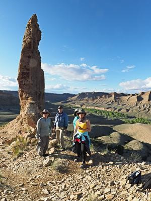
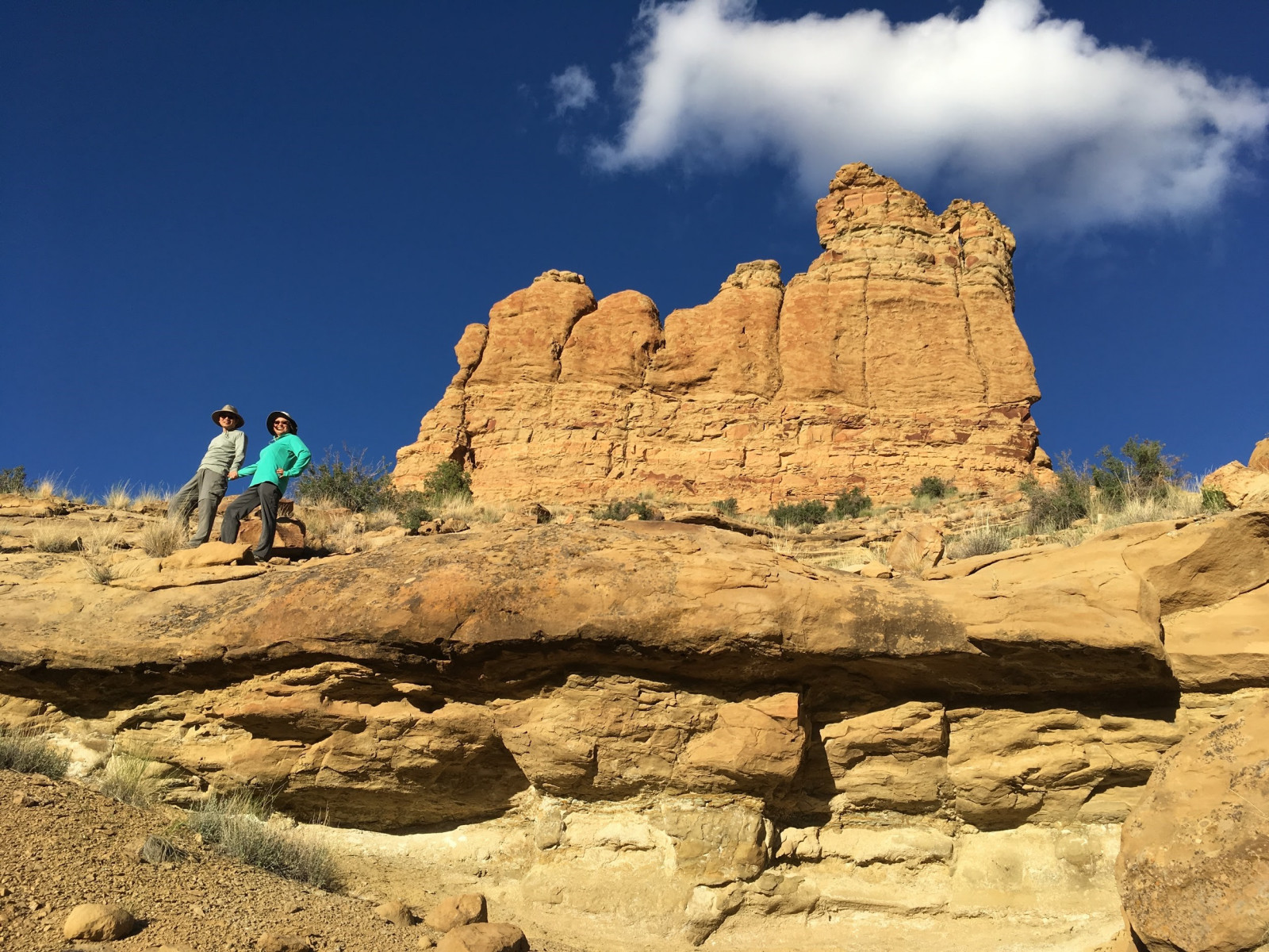
I posted this trip the prior two years, and got no takers – this year, there was more interest and we had a group of 10, in 4 tandems and 2 solo boats, so there are pic’s. First two were from our camp on Friday, after the rain The rest, with blue sky, are from Saturday.
Mat
Click on the image below to manually cycle through the photos.
")
")
")
")

