1/7/2023-1/17/2023
By Tracy H.
Note: In November 2019, a group of RMCC members traveled to Georgia and Florida to paddle the route described below. However, due to very low water in 2019, the route below was closed. So we improvised on the 2019 trip and paddled a different section of the Okefenokee swamp, and then drove back to Florida – to paddle the middle section of the Suwanee River. That was a really good trip. But, I have to say that the route below, which we were able to do in January 2023, is a GREAT trip.
Day 1. This trip was the four amigos, Tracy, Janet, Mat and Judy. We paddled three 14.5’ touring kayaks and a solo canoe. Planning winter paddle trips in the Oke can be hit and miss. Permits must be obtained months in advance. Although this is the deep south, it can get darn cold and water levels are unpredictable. This time we got lucky with weather and water levels. Janet and I arrived at the Canoe Outpost at the Suwanee Music Park on January 6, 2023 and set up camp. Next morning Mat and Judy arrived, we loaded up our boats and gear on the shuttle provided by the Canoe Outpost and headed to Kingfisher Landing on the far east side of the Okefenokee National Wildlife refuge. We got a bit of a late start and the drive was over two hours. While getting ready to paddle a ranger stopped to visit and check our permit causing further delay. It was 11:30am before we got going. We have twelve miles to paddle on this short winter day and we were concerned about reaching Maul Hammock, our first camp before dark. This is not a place to be lost at night. We tried to press but our boats were heavy with 14 days of provisions and camp gear. The water is low and we had several floating peat bogs to pass through. Each mile took nearly 30 minutes and we arrived at camp just a half hour before sunset.
The day was beautiful with a clear blue sky and an occasional light breeze, temperature in the mid-60’s. We knew up front that the level of water in the swamp would be on the low side, and the Suwanee River level was at about 51 or 52’ – also on the low side, but doable. About an hour into our trip, we met a couple in a tandem canoe, returning from their day trip. They would be the only other paddlers we would see for 11 days. The trail through this part of the swamp was about 20 feet wide and mostly brush-lined. Not a lot of views but there were lots of interesting carnivorous pitcher plants along the way. Paddling many hours and miles with no solid land creates a true problem when you need a pee break… A successful attempt without getting wet (from any source) makes you feel like a gifted athlete. An unsuccessful attempt could be disastrous – I wouldn’t know. If the ACA doesn’t have a class teaching the skill of peeing from your boat, they certainly should. We set up our tents at Maul Hammock, and had dinner – while a huge chorus of laughing frogs serenaded us. These were different sounding frogs than what we’d ever heard – they have a Georgian accent?? Or maybe not frogs, but “where the crawdads sing?”… A little after sunset they gave an encore performance. Maul Hammock is a wood platform structure with a porta-potty (like the chickees in the Everglades), set up in the swamp to camp on, because there’s no land to camp on in this area.
It’s just a day past full moon — so a bright dewy night. Owls were calling back and forth throughout much of the night making weird sounds. We are all tired. Janet and I feel like we are out of paddling shape, because we spent much time the past two months over the holidays “getting fluffy”. Day 1 we paddled 12 miles.
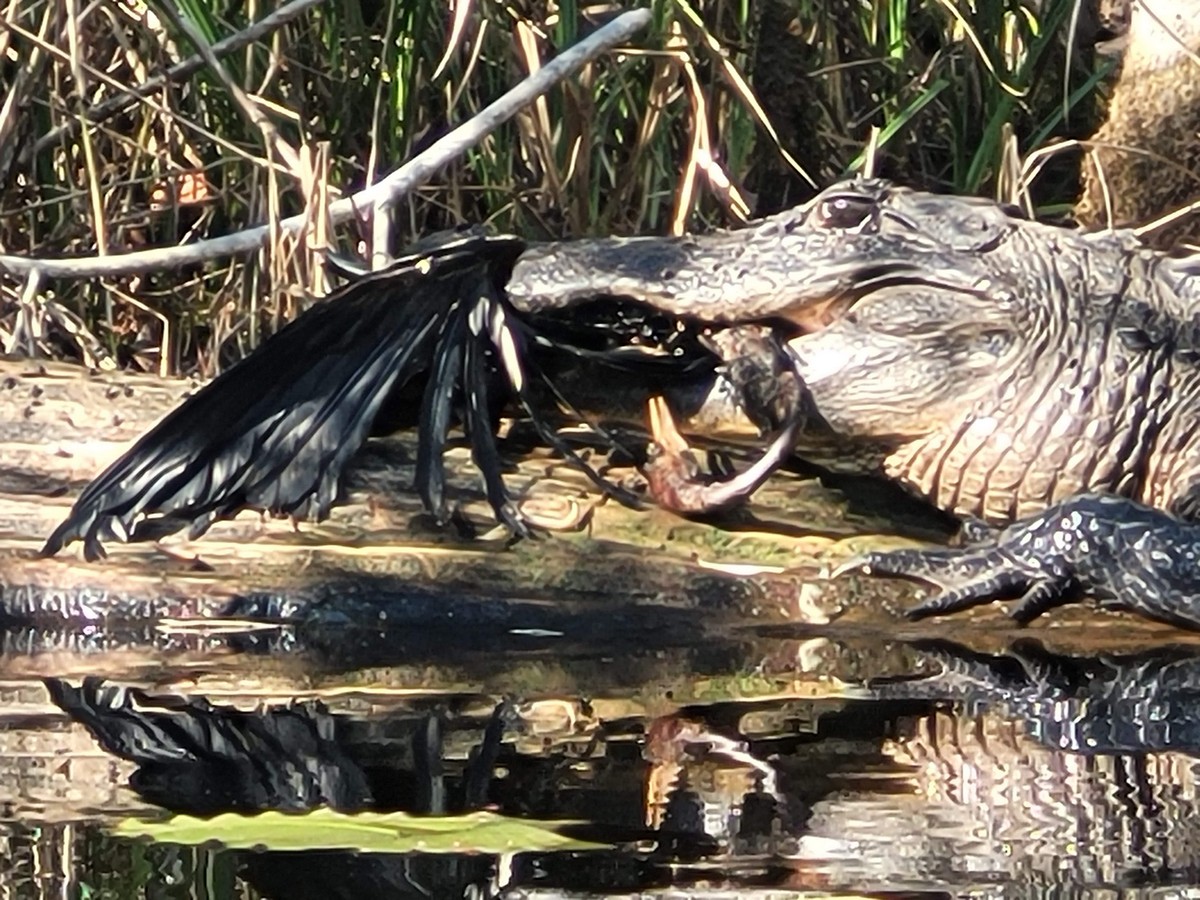
Day 2. It’s a chilly 36 degree morning. Daylight didn’t arrive until after 7 am. We had all talked about how we wanted to have a pretty relaxing trip. In order to camp in the swamp, you have to make reservations well in advance, and you can only spend a maximum of 4 nights in the swamp this time of year (and only 2 nights in peak season). It’s not a very long distance from camp site to camp site. So mornings would be leisurely as far as our launch time, and the daily mileage fairly easy. We’re off by the crack of 9:30. The trail started much the same as yesterday. It’s dead calm, and whoever is lead boat is treated to fantastic reflections on the water. On long narrow stretches with high brush, it feels like paddling through a bottomless canyon, which can make you a little dizzy if you allow it to. Soon the trail begins to cross through open grass watery meadows, then more brush. The last several miles of today’s paddle pass through tall trees that bow over the trail creating a tunnel. Then we pass through a mostly cypress forest. A lot of the trail was very twisty, narrow, and had a nice current in our favor. We saw several gators today – the first of the trip. Most were camera shy, but a mean looking eight-footer stood his ground, while the four of us paddled by within 15 feet of him. We reached our second camp, Big Water (another chickee) by 1:30, and had a nice lunch. This is one of the most remote parts of the Oke. Today there were a few whisky clouds and contrails in all directions. We’ve seen several great egrets, sandhill cranes, ibis, hawks, vultures, cormorants, herons, and several small songbirds. Today Mat spotted tracks leading from the water trail then disappearing off through the bog. They were about the right spacing and size to be really big human tracks – but no human in their right mind would want to stomp through the swamp here, knowing how many gators there are. This just lends credence to the existence of the skunk ape…BELIEVE! Perhaps not ALL the calls we heard last night were owls after all. Today’s 12-mile paddle was truly awesome.
Big Water was a nice quiet camp, surrounded by cypress trees draped in Spanish moss. We had a nice evening visiting around our “campfire” candle. The outhouse here has sort-of a trick lock – and two of us managed to lock ourselves inside (not at the same time). The “other people” on the chickee were reluctant and slow to let them out each time, with a few good laughs that is…. It was a beautiful day in the 70’s. We had a little shower overnight, but the night/morning temperature was much warmer.
Day 3. This morning we have clear blue skies and light breeze, and we’re off by 9:15. The channel is now 60-80 feet wide, winding through a mostly-cypress forest. We spotted several gators and a couple turtles today. We somehow managed to paddle past the shortcut trail to Floyd’s Island, our next camp. But no worries – there’s another route to Floyd’s Island. It just added a couple extra miles to our paddle today. We’d been following the Red Trail so far. But the cutoff to Floyd’s Island is the Green Trail. This trail is super narrow, and very shallow, and we paddled miles through more tunnels of overhanging trees and swamp growth. We spooked up a large flock of sandhill cranes along the way today. What a chorus of protest they made as they flew off… We’re paddling against the current and getting a good workout today. However we still make it to Floyd’s Island by 12:30.
The old cabin on Floyd’s Island is in great condition. Janet and I were here several years ago, and a big tree had fallen and smashed the back room of the cabin. That room is now gone but the wall to the back had been fixed, so there’s two nice bedrooms on either end of the cabin now. We spent the afternoon walking the quarter mile portage trail across the Island and following many game trails. We played cards and horseshoes, and spent time reading the journal left here, that other paddlers record their experiences in. We had our first wood campfire tonight, and we got out our little guitars and made some noise until way past 8pm… Something large walked very nearby in the brush. But we’d all been staring at the fire, and had no night vision to see what it was. We slept in the rooms, on the floor in the cabin tonight. It was nice not having to setup tents for a night. Paddled 7 miles.
Day 4. When I woke, something was different that I’d never experienced before – the first day of my 65th year. What a great place and great people to be with for my birthday. I loved the wood-framed screen door on Floyd’s cabin – brings memories from my youth and that familiar threat “if you bang that damn door one more time…” That never worried me much – I was pretty fast. But there was a time or two that Mom proved she was pretty fast too.
We backtracked down the Green trail, back to the Red Trail, then had a lunch break at Minnie’s Lake shelter. That’s another beautiful spot in the swamp. In a few more miles we reached Stephen Foster State Park and walked up to the office to check out of the swamp –the ranger we met on day 1 had asked us to. We bought some ice cream and we are off. We paddled on to Mixen’s Hammock and arrived about 4pm. We saw close to 40 gators today – which thoroughly delighted Mat.
Mixen’s Hammock is another ground site just off the main trail. We set up camp and had dinner, and another roaring fire. The gang sang “Happy Birthday” to me, and Janet surprised us by sharing decadent Slippery Nipples with all of us – it’s a private joke… It was close to 10pm before the chill chased us into our tents. We paddled about 9 miles today.
Day 5. Today we paddled through a section called “the Narrows”. It starts in a Cypress Forest, then passes through a grass prairie. The current was fast in some sections. And, we saw an otter today. Our next stop is The Sill. We got lucky that one narrow chute through The Sill was not blocked by logs, so we could paddle through it. Otherwise we would have had to portage over.
This is where the Okefenokee Swamp ends. It is such an enchanting place, we hate to leave, but our adventure continues on. We now enter the headwaters of the Suwanee River. Tupelo trees dominate the riverbank now, with a few Cypress intermingled. One of the most magical things about the Suwanee are the beautiful root systems of the Tupelos and the Cypress, with all the artistic patterns they make along the river’s edge – one of the advantages of a lower river level. We paddled down the very slow-moving Suwanee, navigating several huge, downed trees that spanned the river. In one spot there was just one little opening to pass through, and the kayaks made it under the tree “doing the Limbo”. But we had to drag the canoe over the tree.
We’ve paddled 16 miles, and we see very few places to camp. Although we hadn’t seen anyone on the river except for the first hour of our trip – we spotted a guy on a golf cart down by the river on a dirt trail. We asked if we could camp there, and he said it was private property, but it would be OK. It turned out to be a pretty noisy camp, due to some houses and a road about a half mile from our camp, which we could see a glimpse of through the trees. That evening we could hear barking hounds, kids, trains, cars, horns – amazing what you can hear off in the distance. So, we named this Barking Dog camp.
Day 6. We’re off by 9:15 and paddled about an hour, arriving at the beautiful abandoned visitor center in the tiny town of Fargo Georgia. We planned to walk into the town, which is within about ¼ mile of the river. We had skipped breakfast, anticipating bacon and eggs, at the Jill-Billy café in Fargo. We were really disappointed to find out it was no longer open. There’s a new Dollar General in Fargo now. So, we picked up some stuff there. Mat got Calamine, for his nasty poison Ivy rash, that’s getting worse by the day. We paddled about 12 miles until about 3pm, and setup camp on a nice sand bar. It was a warm day, and we stopped along the way for a CHILLY river bath. We saw another otter today. Other than a few herons and ducks, the river since The Sill has been eerily void of wildlife. We had a nice roaring fire on the beach tonight. There was a wild thunderstorm, and lightning flashing through the night. The thunder was loud, often coming simultaneously with the lightning strikes, and it shook the ground that we slept on. There was a lot of rain, but we were on high ground. Guess we’ll nickname this “Thunder Camp”.
Day 7 – Friday the 13th. We were happy to see the river was up a little. It’s a clear chilly morning, and we’re off by 9:40. Today we enter Florida, and the scenery changes some. The river is wider and deeper, and a little straighter, and the riverbanks are high with less Tupelo, and more Cypress. We’re starting to see some limestone outcroppings on the riverbanks. At our lunch stop today, we all put on warmer clothes, as the temperature has dropped and the sky has turned gray.
We setup camp at Scorpion Beach about 3pm, leaving plenty of time for a nice campfire and a little music. Note — if we camp here again, we should go to the downriver end of the beach, much nicer. We saw several otters today. Miles 17
Day 8 – Saturday the 14th. As expected it’s a cold morning. We had our first morning campfire, and boy was that nice. But it caused us an even later start. We had a chilly breeze all day. Just a couple miles past our camp, we had to stop at Turner Bridge, to make a rudder repair to Janet’s kayak. Then we passed through a couple sections of shallow water, where you had to choose your path carefully. But once we reached Cone Bridge, the water was deeper. The two bridges mentioned are long gone, just the name and road access remain. We setup camp on a tiny island in the middle of the river, and prepared for a cold night, gathering extra firewood – so we could have another morning fire. We paddled 15 miles today.
Day 9 – Heavy frost on everything this morning, but no wind. We made a stop at the Suwanee Canoe launch, to fill our water jugs. It’s just a mile upriver from Big Shoals. There’s a warning sign here about running Big Shoals – likening the sharp limestone to a cheese grater, that eats rafts and aluminum boats. We stopped at the top of Big Shoals and hiked the portage trail on river left. The river is close to 100 feet wide here, and the only line is on the far side, and we can’t see it well. So we ferry across the river for a closer look, and hike on down to the rapids. The rapid is about 100 feet long, with 3 separate drops that total about 6 feet. At higher water, this is the only class III rapid in Florida. The first drop has plenty of flow, with some rocks poking out of it. The 2nd drop looks pretty mild. And the third drop is really rocky, no great path, and not much flow, the rocks have just a few inches of water cover …. All literature says to portage here, but the voices are loud and convincing saying “DO IT!!” (Tracy’s anyway). This is our third time here. The first time we were here on a previous trip, the river was at flood stage, and the rapids were roaring and there were strainers – so we portaged. The second time, the river level was higher than now and seemed ideal, and Janet and I successfully ran the rapid, while most of the rest of the group we were with portaged. Luckily, all three drops are a fairly straight shot, which is good for my 14 ½ foot boat, that doesn’t turn like a whitewater boat. I got a little splashed on the first drop, and bounced over rocks on the last drop. Janet was mad, I think she muttered the word “reckless” , and possibly “dumb ass” and she didn’t like the thought of my head dragging on a rocks…. Actually, nobody was very happy with me. Yet, it still took over an hour to wipe the grin off my face. An awkward situation.
We setup camp at the bottom of the Big Shoals and had a nice fire. The Florida Trail passes through here, and 4 hikers were disappointed that our camp was already setup when they came through. But, they setup camp nearby. The end of the portage trail at Big Shoals is a steep, slippery, nasty put-in at this river level. In my opinion, running the shoals is safer than dealing with this, but not in everyone else’s opinion… 7 ½ Miles paddled today.
Day 10. We paddled to White Springs and walked to town. We had a nice lunch at the local barbecue place “Fat Belly’s” – so good not to have rehydrated food or tuna packs…. Then walked to Dollar General for more supplies. After a quick stop at the Stephen Foster Bell Tower, we realized 2 ½ hours had passed, and we had many more miles to get to camp before dark. For those of you who have been to this Bell Tower, the notes about the original words and history behind the “Suwanee River” song were in display cases inside. We didn’t see that this time – maybe we missed it… We gave a quick interview to some guys doing a documentary on the Suwanee River who happened to wander down to our boats. We reached Woods Ferry camp about 5pm, with just a little daylight left. We used the camp carts to haul our gear up the huge switch-back ramp, to the roofed and screened-in shelters – great when bugs are thick. However, surprisingly, we hadn’t had many mosquitoes or no-seeums on this trip. There are 5 of these shelters here, and only one of them was occupied by a nice couple from North Carolina. We were happy the camp host wasn’t here, because we hadn’t made reservations – and don’t know if they would have given us a hard time or not. It felt great to get a hot shower here, the first one in 10 days. These river camps are free, and very nice. There are several more of these camps, but they are all further down river than we are going on this trip. 17 miles today
Day 11. Tuesday the 17th, our last day. We stopped to check out the ruins of Suwanee Springs, once the largest tourist attraction in Florida. Not much left here now. Then on to Suwanee Music River Park, where we had left our vehicles – arriving at 1pm. 11 miles today.
It was a great trip 11 days, and about 135 miles.


