Tracy and Janet’s Big Adventure, 26 Days and 1000 Miles paddling the Yukon River
Many friends have asked us why we never posted our trip report from our 1000 mile paddle down the Yukon River last summer – from Whitehorse in Yukon Canada, to the Dalton Highway Yukon River Bridge in Alaska. Quite frankly, we just thought it was too long to post. It’s tough to summarize, but it will probably forever be one of the greatest trips of our lives. Days without seeing other people, tests of our strength and physical endurance, the raw beauty and magnitude of the wilderness we went through, having just the two of us on this paddle, spotting wild wolves for the first time in our lives, and the ability to totally lose track of time in the never ending sunlight – all contributed to an experience that is unparalleled for us. For those with a distaste for long boring documents, we recommend you stop here. For the handful that proceed, please do so with caution, and be careful what you ask for, this is a 10 kiloword doc, and there will be a test at the end.
Day 1 Sunday 6/30/24. Our camper van is finally loaded with all the supplies for this big trip, and kayaks up on top. We stopped to say goodbye to our son Ben at his shops in Estes, and then our other son Nick in Ft Collins, then on to Billings. From here we were going to go North but changed to West due to big thunderstorm. Camped just North of Big Timber MT, at a gravel pulloff along the road. The many blooming fields of yellow Canola flowers are beautiful.
Day 2 July 1. Crossed the border today, and found out it was Canada Day. So, the normal boat inspection was closed and we had to go inside the building to get our “inspection signoff”. They just asked a few questions and we were on our way. Just before we got to Calgary Canada, we noticed that we had driven almost 1,000 miles – the distance we’re planning on paddling on the Yukon River. That really puts things into perspective – like paddling from home to Calgary – Wow. Got to Banff National Park late afternoon. Since it’s Canada Day, entrance was free! We arrived at Lake Louise at 7pm. Parking Kiosks didn’t work and after 7pm it’s free anyway, so once again we lucked out and didn’t have to pay $36 to park. Saw Lake Louise – beautiful but over-hyped with all the tourists (mostly foreign, oh wait, guess we are foreigners also!) here. We camped at Lake Louise overflow lot. $12 and no reservations honor system. Weren’t sure we had to pay that either due to Canada Day, but we did… Don’t need law encounters this early on in the trip….
Day 3 July 2. We had forgotten how tall, huge, jagged, and spectacular the mountains and glaciers are in Banff. The hillsides are full of waterfalls. Drove through Jasper NP and stopped at Sunwapta waterfall. Saw 2 Black bears and some Bighorn sheep and lots of Elk. No parking at Athabasca Falls, but we drove the bridge slowly and took a good look. Drove through town of Jasper –pretty, but touristy – kindof “Estes Park-ish” (note, a few weeks after we’d been to Jasper, about 30% of the town burned due to a wildfire… sad…) Saw the world’s biggest beaver at “Beaver Lodge”… Found a nice camp by the river near Ft St John. Rained all day. Gas $1.60/Liter. Got to mile zero of Alaskan Highway at Dawson Creek. It had been raining a lot, and almost got stuck in the greasy mud by the river. Glad we have All Wheel Drive in the van.
Day 4 July 3. Rained most of the night. Left early, and continued up the Alaskan Highway. Scenery starts to change after a few hours and becomes mountainous again/beautiful. Stone Mountain Provincial Park has great views. We had driven through it last year, but it was so smoky we couldn’t see much, so this year was a treat. Our main destination today is Liard Hot Springs! Got there about 4pm and stayed about 1 ½ hrs. It’s a great place to relax, and serves as our first real “bath” since we left home. Also saw Wood Buffalo today, and several porcupine along the road. Took a dirt road a couple miles back, after Liard Hot Springs, to Smith River Falls – really pretty. On the way, after Stone Mountain, we checked out a nice campsite/boat launch next to the Toad River. It was vacant except for 1 tent, and free – a good camp to keep in mind for future trips – but we’re not ready to stop for the day yet. Camped about 7pm tonight down a dirt road in what appears to be an old gravel pit, near Fireside. Saw several bears tonight – they seemed to come out near the road around 7pm. We walked down to the river near where we camped, keeping bear spray handy. Also we went to Muncho Lake Provincial Park today, a beautiful long lake with mountains all around.
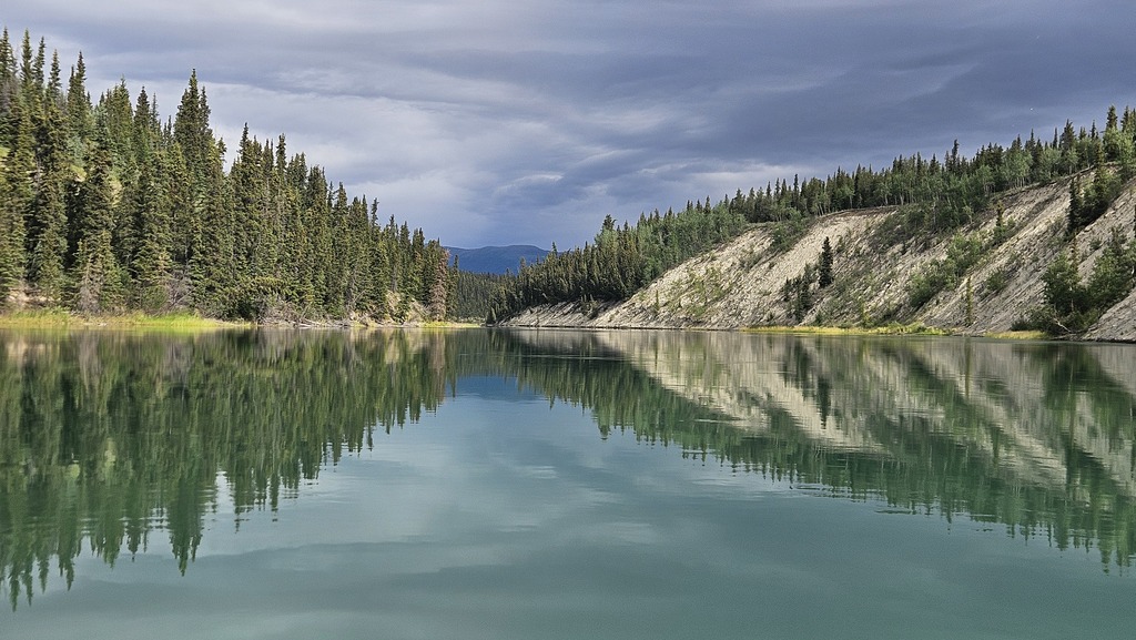
Day 5 July 4. Up early. Lots of bear out close to the road. Stopped at the town of Watson Lake to see the “sign forest”, and found the Florida license plate our friend Judy had left the on our last year’s paddle, with all our name’s on it. Gassed up $1.87/L. On to Whitehorse. We had a great time on the beautiful 2500 mile drive to Whitehorse. Our Yukon River adventure starts tomorrow. It will be our biggest trip ever in both miles and days. Our route will cover approximately 1000 miles, and we estimate it will take 30 days or more. We start in Whitehorse, Yukon Territory, paddling north past Carmax to Dawson City, close to 500 miles. We did part of this section last year with Mat and Judy (last year we put in at Quiet Lake and paddled the Big Salmon to the confluence of the Yukon). This year it’s just me and Janet. We will put in at Whitehorse on the Yukon River, until it runs into Lake Laberge. Then paddle through Lake Laberge, which empties into the Yukon River – a large stretch we missed last year. After we finish the initial 500 miles to Dawson City, we’ll continue into “new territory” for us. Past Dawson, the Yukon river turns NW into Alaska. We will stop in Eagle Alaska to check in with the US customs via phone, then on to Circle Alaska. Just above here we will be above the Arctic Circle a few days, until the River turns SW and we end our trip at the Dalton Highway Crossing – 150 miles NW of Fairbanks Alaska. Tracy has a cousin in Fairbanks, who will hopefully come get us and haul us from here back to Fairbanks. Then we will rent a Uhaul truck to get us and or gear/kayaks back to Whitehorse, where our van is.
We saw a moose and 2 babies today, and lots more bears. We went to the Wildlife Management office to check on wildfires that had closed the road to Dawson City. We wanted assurance our trip would be safe. They said they were taking cars through with a pilot car, so we will hopefully be OK – and “it’s a big river if you come across fire, paddle to the other side”. Just the week before the annual boat race” Yukon Quest”, from Whitehorse to Dawson was cut short at Carmax due to safety concern of wildfire and the road was closed. We stopped at the visitor center and filled our water jugs, so we wouldn’t have to filter water for a while. We went back to the van in the parking lot at the visitor center, and “Mit” and his significant other walked up to check out our van. He gave us his name and phone as an emergency contact for Whitehorse “just in case” – how nice!! He also sent us to Canadian Tire to buy Bear Bangers… we didn’t think they were legal (still not quite sure we can take them through customs later), but oh well…rather have them then not… We went to the boat launch, where we decided to camp. We’ll store the van ½ mile up the road from the launch at Yucan Storage. So convenient, but our camping spot is a bit sketchy with “homeless camp” kind of feel and lots of people driving in and out until late. But, tomorrow’s the big launch day!! No fireworks for 4th of July in Canada… imagine that!! Also, it was still quite late at 11pm when we finally settled down for the night.
Thinking about our trip — we are well aware of the many possible dangers we could face being alone in this very remote country including injury or sickness, wildlife encounters, including bears, moose, and wolves, extreme weather conditions, wildfires, and icy swift water. We have good gear and plenty of experience. Going with a larger group has some safety advantages but can also complicate things. Being part Irish (Tracy that is) helps with luck. But we are well equipped and prepared physically and mentally. We are confident yet humbly cautious with just a touch of crazy. At this point the notion of “not doing this” carries the greatest danger of all. That would be living with regret. Who the hell needs that? So here we go, wish us well, and see you on the flip side. This is our “pre-trip report, just in case”.
Paddle Day 1 – July 5. Launch Day!! Up early in the drizzle and mist. Took a long time to pack our boats because we’ve never brought this much stuff before – more than a month on the river with all kinds of weather. And, some new additions to gear like a bug tent (dangit Mat), bear bangers, a flare gun (uh, for “signaling”, or just in case a bear is afraid of flares??…), way more food, etc. Tracy dropped off the van at Yucan Storage wile Janet stayed with the boats and finished packing.
Finally, ready!! A beaver swims around us and gives us a sendoff as we get in our boats – nice!! The current moves well for a few miles, then, not so much… Left about 9:15 am and paddled until about 6pm, just over 30 miles. We made it to Lake LaBerge – the “Cremation of Sam Magee” lake (for Robert Service poetry fans), and found a beautiful camp about 10 miles up the lake on the right. The lake was fairly calm, although we’ve heard it can be treacherous with wind and large waves – so we’re lucky. Lots of bald eagles today. We’re beat! More beaver at our camp (looked like a young lost beaver swimming back and forth for a couple hours). Also mergansers, and some flying ducks we need to try and identify later – they flew with their head lowered and had a “hunch back”.
Paddle Day 2 – July 6. Wind started howling at 2am from the South. The first 2 hours paddling this morning were a wild ride in the kayaks. Big waves overtaking us from behind – in Florida we call this a following sea. Surfing down the wave face our bow would plow in the bottom of the trough, creating a pivot point. Then the crest of the wave would push the stern, usually right, making us parallel to the waves at the bottom of the trough – not a good place to be. As we paddled north the waves were building more height. I don’t think they got to 4’, but close – enough that we’d just see each other’s heads in between waves. Exciting and ‘fun’ with just a touch of terror. We planned to camp at the north end of LaBerge at 20 miles, but we made good time with the wind, and got there about 4pm with lots of daylight left. If we camp here the wind could increase and pin us down tomorrow, as we are paddling now in conditions close to our personal skill limit –we do not want get into a situation where we need to be rescued. A rescue situation would be time consuming, costly, and perhaps deadly. This trip is already chock full of intrinsic risk, so risk management/good decisions is a priority for us So we paddled a couple more miles to the end of the lake and back into the Yukon River, where the current picks up eventually. As we make some miles, the forest gets smoky on both sides of the river. There’s a wildfire burning a ways off to our right, and we can see nearby trees “explode” with fire now and then … a bit spooky… Eventually we paddle out of the area where the fire is burning. Then on to mile 85 ??? and set up camp at the upper end of an island. Turns out the lower end was much nicer, but a motor boat was there so we stayed at the upper end (he left after a bit, but we’d already unpacked). Set up our chairs on a field of purple flowers by the river, getting a whiff of a familiar scent. Turned out we were sitting in a huge field of either chives or onions… Hope the bears don’t find that too appealing…
Day 3. Beautiful morning – had the rain fly off all night. It’s hard to go to sleep early when it still looks like 5pm at 11pm. Woke up sometime during the night, and it was “slightly dark” – more like dusk. Took a long walk down to the other end of the island – and there are 2 outhouses, a luxury when you’re camping!! One of them is a side by side ‘2-holer’. Why in the world?… there’s a limit to togetherness…. Paddled 46.5 miles today, and the wind was against us much of the time, but not blowing too hard. Highlight of the day was seeing the ruins of the Steamship “Evelyn” on Shipyard Island, just past the confluence of the Teslin River and the Yukon River. We crawled up a sketchy plank to get in the steamship (yep, walked the plank), and explored the ship. Met a power-boat (2 guys) there. They were setting antenna towers up, for tracking and counting the salmon migration in the river. They told us Salmon were already at the Porcupine River. That is hundreds of miles down river from here by Ft Yukon. The Teslin River is a big river, but it didn’t seem to change the flow of the Yukon much. We kept paddling through a huge area that had been burned, looking for a nice camp. Finally at about 40 miles we saw the camp that was marked “very good” camp on our map, and there was a red and green canoe there, dangit… Our first paddlers we’ve encountered on the Yukon, and they’re in the camp we want. Well, it’s a big country – so we press on. Finally we spot a huge island/sandbar (named the “upper Cassiar Bar”) – home for the night! Arrived about 6pm. No outhouse tonight, we were getting spoiled. Weird to see that sort of thing on the Yukon River, since it’s so remote. Guess they’re only on the upper section, as we don’t remember them from last year further along. Beautiful evening on the sandbar and our private island. We went over the 100 mile mark for our trip so far – so we’re already 1/10th of our way through the trip!
Day 4. 9am start. It was chilly this morning – probably low 40’s, but still not bad. Warmed up nicely. Good campfire last night – singing and whistling and bad guitar playing, since we had the world to ourselves, it seemed. And we stayed up late, losing track of time since it was still quite light at midnight. This morning we were going to check out a cabin just before reaching the Big Salmon, but 5 canoes were there, so we went on by. We did stop just past the confluence of the Big Salmon on river right, to see a historic/native Village and Cemetery. We had stopped just a little too soon last year and didn’t find it . This year we wandered a bit, and found the village – and we’re glad we tried again. There are several old cabins, an old trading post building, and a beautiful cemetery with native little spirit houses, set on a beautiful hill where you can see both the river and mountains. A great place to spend eternity… The group of 5 canoes also stopped. They are from Denmark. They left first, and we saw them a couple hours later hiking to an overlook of the Yukon river. We passed them up. Our next stop was Little Salmon Cemetery. They have cleared out a lot of brush – it was all overgrown last year. On to camp at RM184. A nice treed spot about 20’ above the river. However it was right across from a point where the Campbell Highway comes near the river – so it’s strange to hear road noise. Also stopped at Cyre’s??? Dredge and talked to the Danes again. They had come down the Teslin River . We went about 45 miles today, mostly into a headwind – we are worn out ( the GPS says we’re on a total of 147.5 miles for the trip. However historically its about 10-15% lower in miles than other gps’s although waypoints are accurate… don’t know why).
Day 5. Pair of Golden eyes swam by within 10’ of us as we were loading the kayaks. Pretty easy day to the Coal Mine Campground, just above the village of Carmacks, about 34 miles. We had a bacon cheeseburger, fries, cold beer at the campground – and our first real/hot shower since we’d left Colorado. Living the luxury life! There are a few other paddlers camping here. They all came down the Teslin River to the Yukon, and said they really enjoyed it. A couple of guys had paddled from Dawson City to the Ocean (Bering Sea) 12 years ago. One said the Yukon Flats was his favorite part of the paddle. ( I think he is pulling my leg..) Makes us feel better as this is our section of most concern – not much information available about it. The river braids in hundreds of different directions it seems, and all the maps are not too detailed as the river changes every year due to spring flooding. They also mentioned not to leave valuables out in the boats, around the villages (particularly Fort Yukon).
Day 6 July 10. Off by 8:30 am. Stopped about 10:30 for breakfast. Got to the notorious “5 Finger Rapid” about noon, but no troubles running it on river right. We saw a Harlequin duck just before 5 Finger Rapids. A good sign, as we named our S-Corp “Harlequin Pass” years ago – after the beautiful ducks and a mythical place we hoped to someday find. Maybe we just did. Rain has been steady all afternoon, until camp at M254, where an old cabin remains. It has a sod roof with tall grass on it, and just kindof blends into the forest. We camped at this campsite last year. This year the cabin is clean and dry and so we are in the cabin tonight. We set up our tarp outside to sit under, and view the river and the rain, and make our dinner. It was a great camp – perfect.
Day 7. Little later start – 9:45. Chilly and cloudy most of the day. Saw a nice herd of Dahl Sheep up high on Minto Bluff. Stopped at Thoms cabin – really nice spot. Went past the confluence of the Pelly River and stopped at Fort Selkirk to camp at about 5pm. It’s a beautiful setting, across from a long basalt cliff. We explored the First Nation cemetery, a couple historic churches, and lots of clean and well preserved buildings (e.g. old homes, stores, schoolhouse, soldiers quarters). The confluence of the Pelly River and the Yukon River has been a gathering area for First Nation people for hundreds of years. In the late 1800s a Hudson Bay Company Trading post was built here. There were periods of conflicts, due to trade. The Canadian military and the North West Mounted Police also used Ft Selkirk. It was a thriving settlement of native and whites until the 1950s, when roads were built from Dawson City to Minto and Whitehorse. Then it was abandoned. We had met “Frieda”, the First Nation lady who helps manage Ft Selkirk, when we pulled in. She stays in a cabin at Ft Selkirk all summer, and people who help out seem to gather at her place in early evening – a nice family atmosphere. Later in the evening, she brought us wonderful pasta with sausage and crescent rolls. We saved the rolls for breakfast in the morning – what a treat on the river!! We were the only people camping here until late evening, when a couple from Minnesota and their 6 year old whom they referred to as Critter, came in from the Pelly River in their canoe. They became the Critter couple. The evening sky finally cleared and it warmed like a summer day.
Day 8. Chilly/windy morning, but luckily there was an enclosed “common shelter” at Fort Selkirk. So we had coffee, tea, and breakfast inside the shelter. We were off at about 8:20 am this morning. Frieda hollered and waved goodbye to us. When we were at Thoms cabin the day before, we saw an open green dry bag on the bank. We looked at the contents, and saw a receipt showing a rental canoe, and some food, personal items, and a jacket — so we figured the paddlers who left it were paddling down the Yukon. We debated whether we might catch up with them, since the bag apparently hadn’t been there long, or critters probably would have eaten the food in the bag. So, we loaded the bag on the top of Janet’s kayak and hoped we’d find them. We asked at Ft Selkirk if there had been an earlier canoe, and were told 2 people had stopped in, and said they were planning to camp about 12 km down from Ft Selkirk. So, we thought we’d try and catch them today – and, well, we did! They were so happy to get their bag back. It belonged to a father/daughter from Quebec who were canoeing the river together. Her only jacket was in the dry bag, as well as an inhaler for her asthma. So, it all worked out well! We heard from them that our intended campsite for the night had been having bear problems. So, change in plans… We paddled past it, and 10 miles more, to a marginal sandbar camp –but it had a beautiful view. Over 50 miles paddled today, and over 300 miles total for the trip so far. Saw a bear on the mountainside while we were paddling, and some waterfowl that seemed to have the markings of geese from a distance, but were smaller and flew/quacked like ducks. Took river baths to clean up….burr…
Day 9. Wind picked up over night making the tent fly rattle. The wind also brought in lots of smoke from near-by wildfires. Not much sleep. Cold and windy morning, but it’s a tail wind, so we left early. Once on the river the temperature was fine. We were going to have a shorter day and camp after 35 miles at a place marked “good camp” on the map. It was a tough steep climb to a tiny camp spot in the trees with lots of bugs. While checking it out, Thomas and Sasha – the father/daughter duo, stop to visit a while. We saw a moose cow and her calf swim across the river upstream from us. We decided to paddle on, and after a few more miles we camped on an island just before the White River confluence. The wind picked up this evening, so we moved our camp more to the interior of the island and out of the wind. This really upset a momma duck. We finally saw we were sitting less than 10 feet from her nest, so we moved camp back again out to the point of the island and endured the wind. The wind brought in more smoke and our beautiful view was severely impaired. The “critter couple” (i.e. couple with the 6 year old) passed us by and waved about 5:30 pm. They don’t seem to start very early so we will likely leapfrog them tomorrow again.
Day 10. Calm smoky morning. Thinking about the prospectors and explorers that came here more than a century before us. Many young men came with the hope of striking it rich. Today a few old men come here with the hope of enriching their life in their golden years…
While enjoying our breakfast, a sleek yellow tandem kayak came cruising by at a speed we cannot match. The couple paddled in perfect sync while blasting a catchy “Traveling Wilburys” tune. Don’t think we mentioned there is a “Yukon 1000 Race” going the same route as us from start to finish. The race started 7/12 – seven days after we started. They paddle up to 18 hours per day since it doesn’t get dark (they’re required to stop for 6 hours). We have paddled over 360 miles in 9 days. Is it possible they have paddled the same distance in just over 2 days? I think yes. I believe about 30 boats are in the Yukon 1000 and top finishers take 7 – 10 days. If so they are averaging approximately 10 mph.
Shortly after our camp for the night, our first stop was climbing up the mountain at the White River and Yukon River confluence. It’s a beautiful view. However the White is so heavily concentrated with silt and logs and debris it detracts from the beauty. From here we got into a headwind for the rest of the day. We had 12” roller waves with white caps blowing up river – felt like we were trying to go the wrong direction on the river. Each mile was really tough. We met a couple racers about 5pm at RM 430 – a couple Britts in a blue tandem kayak. They were wondering what position they were in and if we had seen a white kayak. We told them no, just the yellow one way ahead of them at around 8:30 am RM 388. We saw the white kayak catch up to the blue not long after we spoke to the Britts. Stopped at Reindeer creek. It’s clear and deep but about ½ mile to camp. The camp is really nice, up high on the bank, and around a bend from the main channel. We were so glad to finally get out of the boat at 7pm. Today’s miles were hard. We worked for every inch. Really hurting back today. Close to 50 mile day, despite the wind.
Day 11. Soaking rain over night. Calm and overcast this AM. There is a curious heavy wire buried parallel with the river up on the bank. It is exposed in several places in camp. We think it’s the old telegraph line. While having coffee and watching the river flow by, we heard wolves howl – sounded like they were on the hilltop above us. That makes the hair on the back of my neck perk up. Spooky. Saw a racer pass by too far away to tell the color. How long can a wolf hold a note? A long time. Talked to a nice couple racers from London later in the day. They think they are in 18th place out of 22 – not sure how they came up with that. They paddled and visited with us quite a while, then took off. Kind of nice getting to talk with Yukon 1000 racers during the race, and keeping pace with them – at least for a while! Made it to Dawson City early afternoon. This is where we ended our trip last year. This year it’s just the halfway point. Lugged all our stuff up the road to the “hostel” where we stayed last year. It’s still as junky and in need of repair as ever. Suits us though… Setup our tent, then took the ferry across the Yukon to Dawson City. There is nothing on the west side where the hostel is. Got a shower at an RV campground in Dawson. Had a great dinner at JJ’s, and ran into the “critter couple” at the restaurant. They now have names – Bear and Clair.
Day 12. Tues July 16. Lay Over Day. Sorted our food to figure out what we needed to resupply in Dawson, for the 2nd half of our trip. Met a fun couple, Dennis and Susan from Anchorage, and had dinner with them in Dawson at the “sour toe” bar/restaurant. No Sour Toe Cocktail for us, we both became members of that prestigious organization last year. Resupplied food, and got Fireball, and a tarp – as we expect to be camping in mudbars in the Yukon Flats. Rained most of the day, so glad we weren’t paddling.
Day 13. Up at 6am. Packed the boats and hauled them down to the river on Dieter’s cart . Yesterday, Dieter (Hostel owner) had his van towed away because he was driving without a license or something like that. We admire his lawless attitude. We put in down river from the ferry so we didn’t get in their way (we took out up river). It’s a chilly foggy morning. From this point on, we’re in a part of the river we’ve never paddled before – so we have a little bit of apprehension. But that quickly dissipates as we get to paddling. There is a saying that “more people have been up Mt Everest than have been beyond Dawson”. Not sure that’s correct but if so, we are helping even it out. Saw the steamship graveyard on river left, and Moosehide Village on river right. Sorry to miss a music festival in Dawson City this weekend and the Moosehide Gathering the following weekend (even years only). Maybe we will be back someday. About noon the fog finally lifted and the sun came out for a while. This really is a beautiful section of river, probably about the prettiest section since we started. Miles of towering cliffs on river right – spectacular! Then the wind kicked in – head wind of course. The last 10 miles were hell. Finally made it to 40 mile camp at 6pm. We were looking forward to this, as our guide book said it was a nice camp with old cabins and a nice caretaker, and Dennis and Susan had also said it was a nice place to stay. But, Oh no…this place got flooded last year and it’s a big mess. Walked around yelling “hello” and finally a caretaker emerged. He told us about last year’s flood and “no place to stay here”. Really disappointed – and we had passed by some good sandbar camps wanting to get to 40 mile camp. Oh well – we paddled on down further and camped at the bottom end of an island (Marmot Island). Turned out it was a pretty nice place. Paddled 52 miles today.
Day 14. Slept well until past 7 am. Nice day of paddling. Stopped at a “fish camp” marked on map. It was a bit of a scramble to get up to it, high up a crumbling dirt bank. This one had a cabin with good roof, out house, picnic table and room for tents. Too early in the day to stop, so we decided to move on, but then the storm that had been building the last couple hours decided to blow and thunder. So we stayed an extra hour and cleaned up the cabin. Off again, then we pulled over a while to let the next blow calm down, then paddled on through rain. Eventually, a small swath is cut through the trees on river right up a mountain , and Boundary Creek is on river left – a small very clear stream. We’ve made it to the Alaska border! A very welcoming rainbow stretches across the border from Canada to Alaska – seems like a good sign! We set up camp on the gravel beside Boundary Creek and the Yukon River. A good place to filter water. We are very cautious when camping where a clear stream intersects the river, as wildlife is also drawn to such areas. It was a beautiful sunset at midnight. Happy to make it to Alaska. And oh, for those of you who wonder, what happens in the tent, stays in the tent…
Day 15. Woke up to a foggy morning. Paddled to Eagle and got out at the top end of the big metal cruise ship wall. Walked up the hill and in to town. Talked to an old timer “David”. He said he fell in love with this small town 40 years ago when he paddled through. He bought the oldest log cabin in town and is still here. He had been a seaman and traveled around the world. Wished we could have stayed longer and heard all the stories hiding in the twinkling eyes. We walked over to the post office to see what information we could get there about the town and area and chatted with the friendly people working there. Then we walked to the NPS Yukon Charlie Preserve Headquarters and talked to “Lucy” for a while. She and Janet had a lot in common being from Wyoming, and living there at the same point in time. Had a real good meal at the giant motel/store/café. It seemed out of place in this town, and we found out it had been built more recently, after a big flood in town. The store was well stocked with food, at least considering how remote It is. We tried to check in with customs as we had read we should – by going to the laundromat and picking up the phone at the phone booth hanging on the side of it. However it was out of service, and we were told it had been out of service for something like 2 years. We really liked Eagle. Time to paddle on though. After Eagle, Calico Bluff was spectacular – and we watched for peregrine falcon which are supposed to nest in the Charlie-Yukon Preserve. Didn’t see them, but thought we heard them. We started looking for a camp site about 6pm, but there weren’t many. We stopped to check out a more promising looking beach camp. But as we looked over towards a log that reminded Tracy of a wolf, Janet spotted 2 sets of ears by the end of the log – which turned out to be 2 wolf pups and a Momma wolf. Decided to move on… The next island beach we stopped at was covered with wolf tracks so we moved on. We finally saw a sand bar at the bottom of an island, a few miles down from the wolves, around 7:30 pm. Long day – about 44 miles, and continual headwinds, kind of like paddling on the ocean with the constant 15 mph wind in your face.
Day 16. Early in the morning, we heard a sound, like a bird that has been startled and flying off (for peace of mind since birds don’t eat you). But, Janet’s initial thought, which she didn’t discuss with Tracy – was that it sounded like a wet dog that is shaking water off its coat. First thing I noticed this AM, after getting out of the tent, were wolf tracks within 15’ of the tent. Enough said. The river has dropped 2-3” over night. Seems like a lot for such a big river. Beautiful sunny day. Didn’t stop at Nelson Public use cabin, because there was a motor boat there, or Nation, because there were lots of tents. Seems to be a gathering place that’s usually occupied. We did stop to see the Glenn Creek cabin. It’s really nice, and even has a “stocked” outhouse (we become grateful for simple thing, e.g. toilet paper..) It’s not time to camp yet so we don’t stay there. We camped at the Kandik River Public Use cabin. It is in real need of repair. Flood has knocked it off its foundation and one side needs jacked up a foot or more. Mosquitos are really bad here. The Kandik River is crystal clear, but where we land the kayaks it’s a soft muddy bottom. I sunk in half way up my calf in the mud while bathing. We saw an eagle and otter near our landing. The journal at the cabin indicates good fishing in the Kandik. We filtered water here – a better choice than the silty Yukon River. Windows on the cabin are covered with nails sticking out, to deter bears. That, plus mosquitoes and a sloped floor, make for a bit of a restless sleeping night.
Day 17 37 miles
There is a big juicy pile of bear scat next to our kayaks tied up beside the river. I’m getting the feeling we are being watched 24/7. We paddled up the Kandik River a ways, its really clear. The map shows it going a long way into the Yukon Territory. We stopped at Slavens Roadhouse. This place is very nice with a two story cabin with lots of beds. The building and grounds are very well maintained. I’m sure a caretaker lives here but no one is around today. There are two small motor boats tied up at the landing here. The Coal Creek Gold Dredge is 1.25 mile hike up Coal Creek. We hike one mile in but the mosquitos were so thick, horrable and unbearable we turned back. Can’t let those damn mosquitos win, we went to our kayaks and juiced up with deet, put on long sleeves, grabbed the head nets and went back. This time we made it to the dredge and we were so happy. This became one of the highlights of our trip. This old dredge is completely intact and all of it is accessible. We toured and climbed every inch of it. It looks like the crew just left for the day, coats and hats hanging on hooks. If someone knew what they were doing they might just fire this thing up and start digging. It’s an amazingly wonderful huge machine that worked until 1976. It is now 5pm but we have only traveled 25 miles today. We considered staying here but we feel a bit guilty for not putting in miles while the weather is so nice. We know the weather can change for the worse any time and likely will sometime before the end of this trip. We did learn a lesson today about hiking in Alaska — mosquitos are not bad on the river and gravel bars, but once you get into heavy vegetation, look out, just a few of those skeeters can carry you off! We paddled a few more hours and decided to stay at the Smith Public Use Cabin for the night. Seems weird staying inside a building two nights in a row. This is a newer cabin although a little dirty inside with some flood mud and silt. We notice an old battery operated cassette player on the table. I hit “play” and we have music, no way! “The Best of Bread” fills our ears. It’s a natural fact that every love sick teen from the 70’s had a copy of this album. The magic of this moment bumped us both about 50 years into the past for a pleasant while. I doubt a stranger thing could happen in this remote country. We stayed in the loft that had a bed and dirty old mattress. We threw a tarp over the mattress and slept in our bags. A soft bed was welcome.
Day 18
In the morning we check out the bear stash on stilts, then notice more wolf tracks on the beach near our kayaks. It was a nice paddle to Circle Alaska today. We just missed a First Nations Festival here that draws natives from all over Alaska and Canada. But, some of the locals decided to keep the party going until the food was gone. They served us hot dogs and burgers, delicious. Everyone here was native and very friendly. This small town has a washeteria ( combination laundry and shower) and a clinic. We talked to Willie, a local, and he told us one of the local fishermen has been missing for three days. He left Circle in a small skiff headed to Fort Yukon and never arrived. Willie was afraid the man got drunk and crashed his boat somewhere. We promised to keep a look out for this missing man. We left Circle with a kind of sick feeling that we might encounter a body. This really affected the whole mood of our trip. We are now in the section of river known as the Yukon Flatts. The river has become huge, very wide and braided and slow with endless channels and islands. Up until this point, we have had a very good and detailed river map. The maps we have from here to the end of our trip leave much to be desired. You just can’t follow the map and know where you are with any accuracy. The Yukon Flatts section is so wide, braided and constantly changes. You could boil 100 pounds of spaghetti noodles, dump it on a flat floor, spread them out with a rake to create a river map as accurate as any other No more mountain views, it’s truly flat country. There are lots of skiffs out searching for the missing person and a couple small planes buzzing overhead as well. It’s hard to tell which route to take. The guide book recommends to just sit still a while and your boat will find the best flow to follow. We paddle until 10pm, and set up camp on a gravel bar, making somewhere between 47 and 50 miles today. Its still bright and hot.
Day 19
Wow , the Yukon Flatts truly is a confusing place to paddle. Just forget about where you think you want to and should go. The river will take you where it wants. Our term “ Its going to suck us down that way” became common verbiage. You can fight the current and occasionally win, but at great expense of energy. It’s hard to trust the current and not fight it when it looks like there is a better/shorter way. It took us too long to realize the river knows best. We didn’t see Twenty Two Mile Village and somehow missed Halfway Whirlpool, a place we worried about getting stuck in and known to spin boats around for hours until they can finally escape. There are lots of smaller whirlpools that can appear form nowhere, they command attention or might flip you if you’re not careful. While taking a break on a large sandbar, a small white helicopter spotted us and landed. Turned out to be Alaska State Troopers. One of the two troopers hopped out and was marching toward us. I swear he looked like a super hero from some action movie. Ok, this might be weirder than “The Best of Bread” from a few days ago. He told us they were searching for the missing boater and a fuel can and life jacket had been found near here. He remarked that because we move so slowly in kayaks we may have a better chance of spotting something. He also told us a dog was with the boater and to watch for one. He gave us a number to contact with our Spot if we see anything. Then the handsome Captain America hopped back into the copter to continue the search. We can’t help but think WTF just happened? We have sort of a history of law enforcement encounters on our paddle trips…but no citations! Later a guy from a skiff told us the dog is a black lab named Ziggy. I guess we are now officially involved in the search and rescue. So much for our wilderness experience, there is more going on here than Disneyland! We did happen on a crashed boat this evening, but it appeared to have been here a long while. But we sent a text the Trooper with a description and coordinates. We scan every inch of shore, any clump could be a body. The paddle has really taken a different feel. We set up our second camp in the Flatts. There are lots of places to camp, but no nice places, just a lot of gravel bars. When the river ice breaks up in the spring, flooding and huge chunks of ice get pushed up on the bars leaving random piles of rock, sand, mud, trees and other debris. Kind of looks like a messy construction site worked over by a dozer with a rookie operator. It’s not all ugly, there are lots more trees bushes and vegetation than we expected to see in the Yukon Flatts. 40 miles today.
Day 20
Beautiful moon last night, it will be full in a few days. Shortly after we started paddling one of the skiff guys we talked to the past two days came motoring up-river. He yelled to us “They found the missing boater last night”. “Is he OK, we yell?” He gives us thumbs up. “The dog?” Thumbs up again! What a relief, we really didn’t want to find a body! We made it to Fort Yukon, we are now north of the Arctic Circle!. We have heard nothing good about Fort Yukon – mainly theft of stuff from boats left unattended while people walk to town. And it’s the last place on the river where booze is legal. The liquor store was closed (bummer) and the town seemed deserted. Seems everyone was attending a funeral. We got some fresh water and took off. Just past Fort Yukon the Porcupine River joins the Yukon. One of the Porcupine braids was crystal clear. It’s been many days since we have seen clear water as the Yukon is very heavily silted. It’s late afternoon and hot, perhaps 90 degrees. Couldn’t resist, we can now claim to have skinny dipped above the Arctic Circle, how about that! The scenery has been much nicer than the flood damaged section between Circle and Fort Yukon. We saw our first fish wheel today. It’s a stationary river powered contraption that scoops fish out of the river and dumps them into a wood holding tank. The operator was there in a skiff. He said he only caught two today. The Yukon Salmon have been in serious decline for years and only native subsistence fishing is allowed. We expected to see lots of fishing activities in this area per our book, but it was written about 20 years ago. I guess things change. We encountered lots of unhappy and aggressive sea gulls today. Perhaps they were protecting nest sites. They kept dive bombing us nearly hitting our heads and shitting at us. They are pretty accurate, but I guess we got lucky. Paddled into a head wind most of the day. We set up camp about 12 miles past Fort Yukon. We made a nice fire and stayed up late, sitting in short sleeves above the Artic Circle, not what we expected. 38 miles today.
Day 21
In the morning Janet found big bear and wolf tracks down the sandbar we hadn’t seen the night before. While we were eating breakfast, we saw Mr. Wolf walking the beach about ¼ mile down river from us and coming our way. We made some noise to be sure he was aware of us. He turned and walked slowly to the point the gravel bar stuck out into the river, paced back and forth a bit, then swam across. We didn’t see him again. Kind of exciting. We had a tough paddle into a brisk headwind today. We earned every one of the 32 miles we put in. Had a little trouble finding a gravel bar to camp on that wasn’t covered in bear tracks. Finally found a huge bar that had no vegetation at all, therefore no bugs, and I can see a mile in every direction. Not scenic, but felt safer.
Day 22
It’s a cloudy chilly and windy morning. We were slow to get going, finally paddling by 10am. It’s a tough paddle day with the wind in our faces. There are small dust storms on the gravel bars we pass. Then rain, not too hard, but driven by wind and it stings the face. We stop often to rest. For the past couple days when we take a rest break, we lie on our backs and wake up 30 minutes later. We are worn out. We were surprised to make it to the small village of Beaver. Despite the wind we are making good miles. We walked up to town, hoping to find a place to get out of the rain and looking to fill our water jugs. We found the washeteria, and were able to fill our water bags with purified water – nice not to have to try and filter the silty Yukon. Being inside a building for a while out of the wind and rain was nice too. We were able to get on their internet and call home, get a weather forecast, and do a quick Facebook update of our trip. When we left Beaver, we started looking for a campsite. We probably stopped 6 or 8 times before we chose one. The forecast for tomorrow is more wind than today, so we will most likely lay over. We are really not that picky about camps, but we don’t want shin deep mud at the takeout or a muddy spot where we’ll have to put our tent, and we do want a little wind protection, and we really want a campsite not covered in bear or wolf tracks. We totally lost track of time today. By the time we found our camp it was 11pm. We unloaded the boats, and set up in the rain by midnight. Time is kind of irrelevant here as it never really gets dark and we are not on a strict schedule.. There is enough light to read at 2am. However our internal clock norrmally tells us the day is done at 5, 6, 7pm and to get going at 6 or 7am. We managed to put in 43 really tough miles today.
Day 23
Last night a strange sound woke me. The wind howled and the rain pattered the tent and the rain fly flapped, making a lot of noise. However the sound that caught my attention was kind of like a child whimpering, giving me the chills. I woke Janet (she loves it when I wake her up in the middle of the night and say “do you hear that”?…), and neither of us could figure out what the sound was. We decided it must be some bird we are unfamiliar with. Maybe this decision is because birds won’t kill you. It went on most of the night – whimpering more when the wind picked up or the rain came down harder. I found no tracks of any kind around the camp this morning. It’s nice to have a rest day – we really need it. I have been thinking of my dad a lot on this trip. His great unrealized dream was to move the family to Alaska for adventure and perhaps a better life. Instead he chose the safety of his home where he was raised in south central Kansas. I’m sure if not for me, my sister, and mom, he would have made it to Alaska. I’ve always felt a touch of guilt about that. Last night I dreamed about Dad. He’s been gone 17 years and I only recall dreaming of him maybe 3 times. This time was so weird and real. He was with us on this adventure and was sleeping in our tent. I woke and quickly sat up looking for him. Of course he wasn’t here. But perhaps he finally make it to Alaska after all. A couple tears I’ve been saving just escaped – probably because of all the blowing sand. But the lump in my throat? Later on, I found out Janet had also dreamed of her mother that night. A night of visiting spirits? Ok see what happens on an idle day. It was really nice to lay around all day, cook a hot lunch, play guitars, and sing. But, mainly we took long naps and hoped for less wind tomorrow. We did find some bear scat on the gravel bar a ways from our tent and wondered when that was “placed there”. We’re getting a bit numb to that at this point.
Day 24 Sunday July 28
Woke up to cold wind and rain. Thought we’d wait awhile for it to warm up and for the winds to hopefully calm down a bit. We finally launched just before 1pm. It was a tough paddle straight into a headwind, no matter if we were going N, W, or S. The wind seems to follow the river channels. Stopped at 8pm and set up camp on Peace Island, just past Purgatory, a small village of about 7 cabins. We hadn’t stopped at Purgatory because it was on the opposite side of the river from where we were paddling – a long diversion. The gravel bar we are on is huge. The darn seagulls attacked us and screeched at us again when we were approaching the island – coming out of nowhere and startling us both. We camp about 50’ from the river and maybe 3” above it. If a power boat were to go by, the wake could flood our tent – but chances of that are remote. I hope our sleeping pads are helpful cushioning the rocks, but we’re getting too worn down to care – the rocks will do. Exhaustion and fatigue has numbed our senses and perhaps dulled our thought process. Heard some sandhill cranes again, and Janet thought she’d heard swans in the early morning.
Day 25 Monday
Paddled 47 miles almost to Stephens Village. Sections of the river are becoming huge. As we were paddling by a big wide open gravel bar – just the kind of place we have felt safe camping on – we saw a bear. When he saw us he started running away, and then he stopped, and started running towards us. The current was taking us towards a narrow spot in the river, where the island sandbar extended out into the river, and the bear was headed for it too. We started yelling at him and slapping our paddles in the water, and he finally turned and ran off into the willows. It drizzled lightly most of the day but we only had light winds – much more pleasant paddling conditions. That’s why we put in extra miles. We actually saw the sandhill cranes on a sandbar today. This section of river is near zero flow – like a lake paddle, and notoriously windy. A big area is called “Kings Slough”. Kings Slough Village appeared to be only a few old cabins – we didn’t stop. Overall we’ve been surprised “The Flats” look more like a forest with sandbars and no hills. Guess we expected miles of mudbars and no vegetation. We debated about trying to paddle further to get to Stephens Village, but the clouds were looking ominous. Found a small sandbar with rocks to camp on, against a steep forested embankment that we’re hoping bears won’t like. We’re wondering when or if our luck might run out with having a bear wander into our camp, with the odd bear behavior from earlier in the day still fresh in our minds. We cooked supper in the rain and set up our tent on the rocks again. I think we’re ready to finish this trip…
Day 26 – Last Day
We had arranged for my cousin in Fairbanks to pick us up at the Dalton Highway bridge this afternoon. We broke camp early. It was a little emotional knowing this would be our final camp and morning on the Yukon. After paddling a few miles, we could see the up-river channel to Stephens Village was completely blocked by a huge gravel bar. We could see a few buildings. The next entrance was down river a mile, and it looked like work to get back to Stephens Village. We didn’t want to be late meeting my cousin and we had no reason to go to Stephens Village other than curiosity. So we didn’t. A ways past Stephens Village we finally made it into the canyon. We hoped the current would pick up, but it didn’t seem to. We saw lots of fish camps today, mostly vacant. And then, we saw the bridge off in the distance – our final destination! Scenes from the whole paddle kept replaying in our minds, as we realized we were almost at the finish line. We made it to the bridge about 3pm – Finally! We’ve made it – our 1000 mile long paddle!! We unloaded our kayaks and set them aside out of the way if anyone else used the ramp. Janet walked up to the truck stop/café in search of a shower – and paid $14 for it. I declined. Our ride showed up about 5pm, delayed by road construction. It was great to see my cousin Jalanda and her husband Ken. We stayed at their house 4 days. They were such gracious hosts, showing us around the area, and over feeding us. Jalanda is a fantastic cook – and spoiled us with Salmon and Halibut that they had personally caught – wow! We also went to a great restaurant 1 night, and drove up to North Pole Alaska, where we saw Santa and his reindeers. If we lost any weight on our 26 day adventure, we gained it all back plus some while here. We had reserved a Uhaul truck with a 10’ box to get back to Whitehorse where we left the van. Originally, we really had no idea how long the paddle would take us, and I had reserved the truck for a week later than our arrival, thinking the paddle would take longer. No trucks were available until finally a 20’ box truck came in – so we took it. It was an extra $100 and ridiculously large for 2 kayaks, but oh well. We did research how to get us and our kayaks back to Whitehorse and Uhaul was really our best and cheapest option. The truck rental was about $800 + gas. Our biggest expense for the whole trip was gas, around $2500. Then food, gotta eat wherever you are so we don’t count that. It’s about 600 miles by road from Fairbanks to Whitehorse. We spent one night camping in the back of our Uhaul – something we’d never done before… Made it to Whitehorse the 2nd day of driving and drove back to our van, which we’d left in storage. Seemed strange to be back at the beginning of where our whole paddle adventure began. Our trip home was a lot of fun too. Did we mention we were aware that Mat and Judy were ending a trip in the Northwest Territory about this same time and were somewhere in the area? We ran into them in an obscure camping area somewhere in Northern British Columbia, small world proven again. You can travel near the end of the earth and still no privacy to be had!
The End
Test
1 How many people have been beyond Dawson?
2 What river enters the Yukon just before Ft Selkirk?
3 Name the last settlement on the Yukon before the Dalton Hwy Bridge.
4 What Creek on the Yukon divided Canada from Alaska?
5 Who was cremated on Lake LaBarge?
6 What recorded music did we hear in one of the river cabins we stayed at?
7 Who did we meet on our way home?
8 What weapon did the seagulls use against us?
9 What was Dieter’s crime?
10 What was the missing Lab’s name?


